MARK PARISH COUNCIL'S WRITTEN RESPONSE
DATED 11 FEBRUARY 2015
MARK PARISH COUNCIL
WRITTEN REPRESENTATION TO
NATIONAL GRID’S
DEVELOPMENT CONSENT ORDER
HINKLEY POINT C CONNECTION PROJECT
PINS REF EN020001
MARK PARISH COUNCIL REF 10029583
FEBRUARY 2015
SECTIONS 1-10
1) MARK PARISH COUNCIL AND ITS PARISHIONERS STRONGLY OBJECT TO THIS PROPOSAL.
2) MARK PARISH COUNCIL’S LETTER TO NATIONAL GRID 2009
3) NATIONAL GRIDS DESIGN AND ACCESS STATEMENT MAY 2014
4) INFORMATION PROVIDED BY NATIONAL GRID
5) ROUTE ALIGNMENTS THROUGH MARK
6) VISUAL IMPACT
7) SOUTHWICK ROAD REVISED ROUTE CONSULTATION FEBRUARY 2014
8) TRAFFIC AND TRANSPORT
9) MITIGATION
10) THE FUTURE AND SITE VISITS
PHOTOGRAPHS
PAGE 11 } ASHTREES, MARK CAUSEWAY
PAGE 12 } WAINBRIDGE FARM AND COURT FARM, MARK
C AUSEWAY
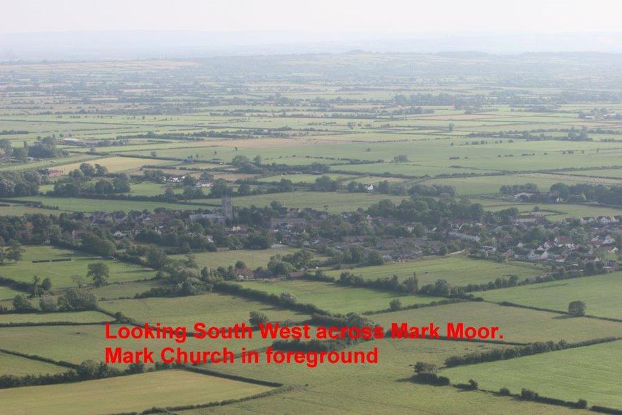
PAGE 13} VIEW OVER MARK MOOR SOUTH WESTERLY
DIRECTION
PAGE 1
MARK PARISH COUNCIL
Richard Young 5 Channel Court,
Clerk of the Council Burnham-on-Sea,
Somerset,
TA8 1NE
Your Ref: Tel: 01278 789859
13 February 2015
Mr C White
Senior Case Manager
Hinkley Point C Connection
Major Applications and Plans Directorate
The Planning Inspectorate
Temple Quay House
Temple Quay
Bristol
BS1 6PN
MARK PARISH COUNCIL RESPONSE TO HINKLEY POINT C CONNECTION EN020001
REGISTRATION NUMBER 10029583
Dear Mr White,
Mark Parish Council is the duly elected representative of the parish of Mark which lays south in Section B on the Somerset Levels, the Council believes that it had 3 key roles in responding to National Grid’s options for the Hinkley Point C Connection Project.
These were:
1) To ensure that local people were properly consulted,
2) To reflect their views on the adequacy of consultation and on the information provided in responding to National Grid,
3) To inform other relevant statutory consultees of the views which Mark villagers and the Council hold on the form and content of the consultation.
In doing so, the Council focussed on the process of public engagement, including public meetings, public information and campaigns groups, it has worked closely with Badgworth and Compton Bishop Parish Councils over the last five years and now has a mandate from its Council to join with these Parish Councils in their responses to PINS.
The three councils have shared information gained from residents and from meetings held with National Grid, it believed that the emphasis which Government legislation and guidance places on the importance of adequate consultation should be used by all. Moreover, the Council believed that other individuals, County and District Local Authorities, were better placed to address the complex technical issues in play.
Mark Councillors do not possess the knowledge and understanding of the complexity of this technical proposal it has been guided by Sedgemoor District Council and has sort from others within the community that do possess this information as to its response to National Grids proposal.
The Council together with Badgworth, Compton Bishop and Wraxhall & Failand PC’s produced a critique for stages 1-4 of the consultation it was sent to Chris White Senior Case Manager 9th June 2014. It gives all information and references to support issues raised in our written response. The cost of this consultation over the five years has been in the region of £20m has this been taken into account by National Grid when making their calculations on cost of the line it would be interesting to have the answer to this.
The Council does however understand the views of its parishioners and the visual impact that this proposal will have and the long term effect upon our village environment.
PAGE 2
Mark is a rural village of 1400 parishioners situated on the environmentally sensitive Somerset Levels to the south of the Mendip Hills AONB. It has the distinction of having been included in the Guinness Book of Records as the longest village in the country. It is still very much a working village although in recent years there has been a noticeable increase of residents commuting to work in the surrounding towns.
Mark is still very much a farming community as well as some local small industries which employ local parishioners; it has a good community spirit.
The visual impact of National Grid’s proposal will have a detrimental impact on the community and the overall village landscape and surrounds. The idea of a 400,000 volt transmission line on 36 metre high pylons running through the middle of the village in between homes and across virgin countryside is causing great concern to the parishioners of Mark.
It is fully understood that National Grid will have to deliver an upgraded electrical transmission system to accommodate the needs of Hinkley Point C, and that the company will also have to plan for renewable energy sources which are being proposed. National Grid was to achieve this upgrade by means of a new 400,000 volt overhead transmission line from Hinkley Point C to Seabank at the time the Atlantic Array was in planning together with on-shore wind farms and the lattice pylon was proposed for the overhead line.
We have since seen the plans for the Atlantic Array withdrawn and onshore wind farms rejected, thus taken out of the equation. The T-Pylon was introduced as an alternative design to the lattice pylon, the height of this being 36 metres making it taller than the existing 132,000 volt pylon at 25 metres high, the Parish Council understands that National Grid has as yet to achieve the construction of a prototype line of T-pylons.
As stated at the Preliminary Meeting 19th January there will only be two poles of the T- pylon type erected and that they would not have the T bar with the diamond spread wire carrier or cables in place at the time of the proposed April site visit. This is a complete failure on the part of National Grid to demonstrate the visual impact of this new transmission line construction.
The proposal by National Grid to introduce a 400,000volt overhead transmission route from Hinkley Point to Seabank which would in part cut across the Somerset Levels and through Mark is primarily based on achieving the lowest possible installation cost without having due and proper regard to the social, economic and environmental costs associated with a 400,000 volt transmission line.
1) MARK PARISH COUNCIL AND ITS PARISHIONERS STRONGLY OBJECT TO THIS PROPOSAL
Mark Parish Council believes that the following statement has not been met within paragraph 2.8.4 of the National Policy Statement EN5.
‘2.8.4 Where possible, applicants should follow the principles below in designing the route of their overhead line proposals and it will be for applicants to offer constructive proposals for additional mitigation of the proposed overhead line. While proposed underground lines do not require development consent under the Planning Act 2008, wherever the nature or proposed route of an overhead line proposal makes it likely that its visual impact will be particularly significant, the applicant should have given appropriate consideration to the potential costs and benefits of other feasible means of connection or reinforcement, including underground and sub-sea cables where appropriate. The ES should set out details of how consideration has been given to undergrounding or sub-sea cables as a way of mitigating such impacts, including, where these have not been adopted on grounds of additional cost, how the costs of mitigation have been calculated.’
However, National Grids recent announcement acknowledges the benefits of undergrounding
On Monday 10-11-2014 National Grid announced that:
National Grid’s £500m plan to move biggest and ugliest pylons underground in eight national parks and areas of outstanding natural beauty and £24m set aside for measures in other areas. Having decided these are the biggest and ugliest ones we now have to look at the feasibility of undergrounding,
The scheme called the Visual Impact Provision (VIP), is to make use of a £500m allocation by Ofgem to reduce the visual impact of existing overhead lines (that were built in the 1950s, 60s and 70s) in National Parks and AONBs and £24m is to be set aside for landscape enhancement initiatives such as planting trees
PAGE 3
and other types of screening. Thus, taxpayers/consumers are paying twice for these transmission lines. Once to construct the overhead line, and secondly to have them buried.
National Grid, having stated cost as a factor in not going subsea or underground in 2009, now finds a considerable amount of money at its disposal for other projects.
So why does Somerset as a County have to house T-pylons under a new project proposal. Mark Parish Council asked this question of National Grid, email November 2014 to Peter Bryant, only to be advised that the Hinkley Point C Connection was already underway and would not be considered in this Visual Impact Provision (VIP).
Note also that the consultation was based on a four year construction programme of work. The period of construction has now been extended to six years as was stated by National Grid at the preliminary Meeting 19th January that the connection date will now be from Q1 2016 to Q2 2022. This is unacceptable to the Council as the public have not been informed of this new date and to have the works extended by two more years will be intolerable to the community as a whole. Therefore the impact on the poorly addressed socio-economic issues will be considerably greater and these have not been taken into account during the consultation.
Mark Parish Council is of the view that the consultation exercise and the public information are inadequate. The following are details of what has transpired over the last five years.
National Grid did not offer the residents of Mark any alternative choice as to how the connection could be achieved and therefore did not engage in a meaningful or genuine consultation on the alternative methods of transmission.
Mark Parish Council has argued from the outset that National Grid’s consultation exercise in October 2009 was fundamentally flawed:
2) The following is taken from the letter sent by Mark Parish Council to National Grid in December 2009.
“In considering the proposals, the Council were concerned at 2 aspects of the consultation process which they believed were unsatisfactory in that they failed to provide sufficient information on which the Council could confidently come to a conclusion.
First, it was not reasonable at the November 16th presentation at Mark village hall for National Grid to propose one option (Corridor 1) without being able to tell consultees whether it would involve 1 or 2 lines of pylons, its own and that of Western Power. The impact of 2 lines would be considerably greater than one; consultation should have made clear which was being put forward. At the presentation made on the 9th November, Peter Bryant clearly stated that there were two options to consider in corridor 1. There is an inconsistency in the information that was given at the two meetings.
Second, the Council believe that the consultation should have made clear which options had been discarded and for what reasons. It considers that it was not reasonable to offer for comment only 2 options, both of which would impact on the village, and thus deprive consultees of the opportunity themselves to test alternative approaches.”
This view was endorsed by local MPs, the planning authorities, other parish councils and local campaign groups. The Council’s principal objection was its belief that National Grid’s approach was to persuade the local population to the principle of an overhead line solution while denying them the opportunity of considering and commenting on other options.
Both proposed route corridors impacted on the village of Mark. Whichever pylon route National Grid chose would adversely affect the visual landscape even though alternative connection options did and still do exist, Subsea/Undergrounding/Gas Insulated Lines. Belatedly, National Grid did acknowledge that their consultation was inadequate.
The Parish Council argued in its letter of December 2009 that the right response to this acknowledgement and one consistent with the Guidance on pre-application consultation, was for National Grid to stop their consultation and to restart it with all the main transmission options explained objectively and offered for comment and consideration.
PAGE 4
In doing so, National Grid should tailor the consultation to meet the needs of ordinary members of the public who have an intimate knowledge of their surroundings and the needs of their community, but possess a limited or no understanding of the technical issues involved. Despite the admission of the inadequacy of their consultation, this was an approach which National Grid refused to adopt.
3) NATIONAL GRID'S DESIGN AND ACCESS STATEMENT MAY 2014 STATES THAT:
4.3 Section B – Somerset Levels and Moors South
5.2.2 The Electricity Act confers a duty upon National Grid under Section 38 and Schedule 9 to ensure that it has regard to amenity when carrying out its undertakings. Schedule 9 states that a licence holder, such as National Grid, has a general responsibility when formulating proposals for new electric lines to: “have regard to the desirability of preserving natural beauty, of conserving flora, fauna and geological or physiographical features of special interest and of protecting sites, buildings and objects of architectural, historic or archaeological interest; and shall do what it reasonably can to mitigate any effect which the proposals would have on natural beauty of the countryside or on any such flora, fauna, features, sites, buildings or objects”.
5.2.3 Schedule 9 also states National Grid has a responsibility when assessing the effects of its proposals to: “mitigate any effect which the proposals would have on the natural beauty of the countryside or any flora, fauna, features, sites, buildings or objects.”
5.2.4 It is these key responsibilities and objectives which underpin National Grid’s design
principles on which the Proposed Development is based.
National Grid’s own literature circulated as part of the public information campaign describes the need for feedback from consultees in the following way:
Source: National Grid Project News Summer 2010 page 8
You’re Feedback
“The decision on a preferred route corridor [for pylons] will be influenced by your views, so we want to understand your preference, interests and concerns “and then under
Next steps
“We will explain why the preferred route corridor has been selected and how you can give us your views on where in the corridor you think the overhead line should go.”
This makes it clear that National Grid’s only agenda was an overhead line in one of the two corridors running through Mark. In pursuit of this objective they provided information in written and disc format and made staff available to give advice and information at drop-in sessions.
The Council believes that this process was an attempt by National Grid to focus solely on the overhead line rather than enter into a meaningful consultation on alternative options. As a consequence National Grid did not engage with the public in a genuine or proper consultation.
By their own admission, National Grid’s huge resources have been marshalled to reinforce their initial proposition rather than to seek ways of meeting local demands for other options to be objectively considered.
4) INFORMATION PROVIDED BY NATIONAL GRID
The information primarily served the purpose of advising villagers of National Grid’s general approach to transmission through overhead lines. However, the Parish Council believes that this failed to recognise or indeed acknowledge the adverse impact of the proposed project on the community and the environment. The technical issues featured in the DVDs were generally too detailed and or complex for the general public or members of the Parish Council to make any meaningful response. However, both parties are well placed to express informed views on the project’s impact on the village.
References, for instance, to the undesirability of short sections of undergrounding in an otherwise overhead connection leave villagers unable to judge, if the project were to go ahead, the extent to which undergrounding would be used by National Grid to overcome local objections, for instance through mitigation of visual impact. Nor was it clear what the balance would be between the visual impact of the proposed pylons and the infrastructure needed at the Sealing End Compounds at either end of the under- grounded section.
PAGE 5
NATIONAL GRID ACCEPTS [NEWSLETTER PAGE 7]
“there is some evidence to suggest that higher than normal exposure to magnetic fields could be linked to an increase in childhood leukaemia”. It is understood that childhood leukaemia peaks between ages 2 to 5.
The example of the Guidance on pre-application consultation, which National Grid were required to adhere to, makes it clear that there should have been a dialogue on the benefits which a proposal might have for the communities it affects, over and above the advantages to the country at large. There was no such dialogue. The only benefit, if it can be called that, to which National Grid have referred to is the dismantling of the existing Western Power line. Villagers are thus left with the assumption that there will be no benefit, but rather a substantial disadvantage resulting from National Grid’s proposal.
National Grid has not involved all local people whose interests are likely to be affected by overhead lines.
The choice of whom to send the material appears to have been based on the principle of choosing those residents in, and within one kilometre of the route corridor. However, this failed to involve a proportion of people whose interests might have been affected? There are two notable categories of such people,
First, the system of land tenure and farming practice in Mark is based for many people on a mixture of usage of land on the Levels, i.e. in and around the village itself and on the Moors in areas further away.
A distribution of information based on residents living in or 1 kilometre distance from the route corridor will not have captured the substantial number living outside Mark or within the outside one kilometre band.
Thus, farmers owning or renting grassland on a widely dispersed field system, often involving fields several miles apart will not have been consulted. An attempt to consult such people on the basis of only those living in or within one kilometre of the corridor is likely to have failed to capture all those with an interest.
Second, the pre-school and school-age children attending Mark First School come from a wider geographical area than simply the village itself. Such is the reputation of Mark First School that it is popular with parents living elsewhere; 60% (figures obtained from Mark First School) of children at the School come from outside the parish of Mark.
Consultation and information
On specific issues the Council believes that National Grid
- Has failed to take account of the full visual impact of the project on the whole area both during construction and the live time of the pylons.
- Has not considered the environmental impact on the area or the detrimental impact on tourism.
- Has not considered the blight to property overshadowed by the visual height and proximity of the pylons within the community of Mark
- Has not fully considered the potential health hazards to the community, particularly in relation to the incidence of childhood leukaemia resulting from living/playing within close proximity of electromagnetic fields created by 400kv lines
- Has failed to provide sufficient information on any proposed Community Benefit.
- Has failed to take notice of local Town/Parish Councils, Bridgwater-Without, Woolavington, Mark, Biddisham, Compton Bishop, Wraxall&Failand, Nailsea and Portbury who have all said “No to pylons”.
5) ROUTE ALIGNMENT THROUGH MARK
A deficiency in National Grid’s consultation is the absence of any meaningful discussion of alternative technological and geographic alternatives to the overhead route proposed. The line is now being proposed to run through the centre of the Mark village which will be seen for miles from the surrounding Somerset Levels and Moors, no amount of mitigation will conceal the T-pylon. The residents of Mark are faced with the prospect of an overhead line mounted on 36 metre high T-pylons running across Mark Moor up over Mark Causeway B3139 in between Wainbridge Farm and Court Farm, the proposal is to site a T-pylon some 41 metres from Court Farm, with the line then continuing North crossing the A38 to Tarnock and Biddisham and on to the Mendip Hills AONB. The prospect of
PAGE 6
having an increase of power from132,000 volt to 400,000 volt on an overhead line in close proximity to homes continues to cause considerable anxiety and stress to residents.
In November 2012, when National Grid’s “preferred route corridor” was announced there were several properties in Yardwall, Southwick Road and Mark Causeway who believed that they had previously been outside the proposed route corridor, discovered without due notice, that they were now to be affected due to a re-alignment of the route. National Grids words: “we have found a larger gap further along the Causeway” This came as a dreadful shock to those householders. The Council is of the view that this further illustrates the inadequate, partial and limited extent of the consultation, falling short of the level of engagement, openness and fairness normally associated with a consultative programme.
6) VISUAL IMPACT
It was in 2012 that the T-Pylon was proposed to replace in parts the lattice pylon along the route, as stated In National Grids News Release paper,
T’time in the South West
Residents feared that the new 400-000kv pylons needed to carry the wires would be much higher than those on the existing 132,000 volt line currently running along the route. However, at 36 metres high the T-pylon is nearly one third shorter than the traditional 400,000 volt lattice design.
DRAFT ROUTE OVERVIEW REPORT AUTUMN 2012 VISUAL IMPACT PAGE 10
We listened carefully and we have tried to minimise the visual effects of our proposals, we will remove the existing 132,000 volt overhead line between Bridgwater and Avonmouth substations, make the proposed new line as straight as possible and consider the use of the lower height T-pylon.
And again in their
PUBLIC CONSULTATION OVERVIEW REPORT SEPTEMBER 2013 PAGE 22
We propose to use the T-pylon for most of the overhead line in this Section (being section B) Due to the lower height, the T-pylon blends more easily into the distance in this landscape.
There will be no reduction of the visual impact as stated by National Grid with the introduction of the T-Pylon being proposed to replace the existing 132,000volt pylon 26 metres high running along the proposed route in Mark. The T-pylon stands at a height of 36 metres, with a cable spread of 31 metres diamond point to diamond point carrying the 400,000 volt power cables.
It is this detrimental negative impact of the proposed T-pylon which is totally unacceptable to the parishioners of Mark and surrounding villages.
In February 2014 National Grid consulted on the Southwick route, several residents had asked National Grid if the line could be moved further east of the pre application alignment as in s42 route, thus bringing the line out onto Mark Moor. The proposal was to be:
7) SOUTHWICK ROAD REVISED ROUTE CONSULTATION FEBRUARY 2014
Southwick Revised Route Consultation
Preliminary Environmental Information Report
2.3 Description of Section 42 Alignment
2.3.1 The Section 42 Alignment is shown on Figure 2.1.
2.3.2 From proposed pylon C-LD10 to the north of the River Brue near to Cripps’s Farm,
the Section 42 Alignment would be aligned in a northerly direction as far as pylon
C-LD14, which would be located to the north of Southwick Road, east of Chestnut
Farm, Southwick.
2.3.3 Between pylons C-LD14 and C-LD16, approaching Mark, the line would run in a
north-north-easterly orientation, east of Yard Wall Farm and broadly parallel to
Yardwall Road.
2.3.4 From pylon C-LD16, the line would run north, crossing Butt Lake Road, and then
Mark Causeway at the eastern edge of the gap between Court Farm and
Wainbridge Farm, crossing Northwick Road and Northwick Rhyne to proposed
PAGE 7
pylon C-LD20.
2.3.5 The Section 42 Alignment is 3.11 km long and would use 11 T-pylons.
2.4 Description of Proposed Alignment
2.4.1 The Proposed Alignment is also shown on Figure 2.1.
2.4.2 From proposed pylon LD10 (in the same location as C-LD10) the Proposed
Alignment would run north-easterly as far as proposed pylon LD13 adjacent to the
track running south from Southwick Road near Knowle View Farm.
2.4.3 The line would travel in a northerly direction to pylon LD15, crossing Southwick
Road.
2.4.4 From LD15, the line would converge with and cross the Section 42 alignment as far
as proposed pylon LD17, which would be located to the west of proposed pylon CLD17
to the north of Butt Lake Road.
2.4.5 From pylon LD17 to LD20, the Proposed Alignment would be similar to the Section
42 alignment, but would cross Mark Causeway further west between Court Farm
and Wainbridge Farm, which would be enabled by the demolition of one residential
property south of Mark Causeway. This property is shown at Figure 6.4.
2.4.6 It would then cross Northwick Road and Northwick Rhyne to proposed pylon LD20
(in broadly the same location as pylon C-LD20).
2.4.7 The Proposed Alignment is 3.29 km long and also would use 11 T-pylons.
The residents living in Southwick Road had an active part in the consultation with National Grid.
During the consultation in September /October 2013 they approached National Grid asking if the line LD13 and LD14 could be moved further east on to Mark Moor thereby taking the line away from the dwellings in Southwick as proposed by National Grid in s42 where it was proposed that the line will run between the dwellings. This time National Grid did stop and listen to what was being asked of them and went on to Consultation in February 2014 when the proposal to move pylons LD13/LD14 was made and supported by the Parish Council and Sedgemoor District Council much to the delight of a few local residents in Southwick. While this amendment helped those residents, it did however move the line east of the residents in Yardwall who also had been asking National Grid to move the line back to pre 2012 position.
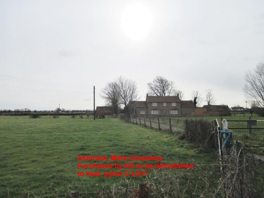
These impacts on homes in Southwick where it over sails Southwick Farm C-LD14 and Reed Farm C-LD13, also in Yardwall the line has now been moved in front of the dwellings. National Grid purchased one property known as Ashtrees on Mark Causeway as the proposed line C-LC17 over sails the property. Wainbridge Farm and Court Farm will host C-LD18 T- Pylon between their properties.
By definition the Somerset Levels and Moors are a flat open landscape some twenty to thirty miles across, which in 2008 were proposed as a World Heritage Status but in 2010, unfortunately, due to lack of funds by Somerset County Council the projected had to be cancelled. The topography means that there is no way that landscaping by the creation of woodlands could mitigate the view of 36 metre high T-pylons crossing the Levels and Moors. Furthermore, large scale tree planting would be alien to the landscape. T- Pylons would be clearly visible from Brent Knoll (ancient hill fort owned by National Trust) the Polden Hills and the Mendip Hills AONB. The visual impact on the landscape of the pylons would be even greater when viewed from the ground upon the Levels.
As a consequence therefore the Somerset Levels and Moors should not be developed with this industrial infrastructure as proposed by National Grid.
Volume 5.7.1.1 Visual Effects Topography and Landform
consideration has been given to whether the Proposed Development would be looked down to looked up to or whether it would be viewed on a level and views up to a development are generally considered to be of greater magnitude due to the enhanced verticality of the structures than views down to a development where the height appears reduced
8) TRAFFIC AND TRANSPORT PLAN &VIBRATION
Volume 2.2 Construction Vibration
14.2.42 Vibration from construction traffic is most likely to be caused by poor road surface on haul roads. On the public highway, vibration is proportional to noise generated and effects will be similar to those generated in table 14.7 this will tend towards negligible effects.
National Grid should have made local communities fully aware of the work plan implications prior to the submission to the Planning Inspectorate. The impact of the construction work is not understood by the vast majority of those living close to the proposed construction path.
PAGE 8
Each Parish should have had a public meeting with explanations before the submission to PINS. The Council believes that the construction work associated with the erection of the pylons will cause significant disruption to Mark and surrounding areas; it will have a detrimental effect on the community and the residents, and will impact significantly on tourism, there being several caravan sites in the village. The Council is of the view that insufficient information has been made available to enable residents to appreciate the significance of such a project and the impact and disruption of the works to be carried out in the village.
Mark is a rural village with the B3139 running through it covering some three miles west to east.
There is no footpath or kerb edging constructed on the B3139 through The Causeway and Mark Causeway or the adjoining roads; there are several single track roads in and around the village which are not suitable for heavy construction traffic, even on a temporary basis, and the level of disruption to local residents for the period of construction will be severe. Southwick Road, Yardwall Road are single track roads with poor road surfacing, Harp Road and Mark Causeway are noted as haul roads, and leading into Back Lane (AX23/10) between Court Farm and Wainbridge Farm will pose a significant disruption to the flow of traffic along the Causeway, how will the crossing of Mark Causeway be managed? It’s noted that National Grid will have banks men in place on the bell mouths in Mark to guide the construction traffic in and out of said bell mouth, it is hoped that this will alleviate the need to use Mark Causeway.
Back Lane is to be used as the exit for the line moving north, the Council asked National Grid if they intend to surface this drove as it is currently just a mud track used by farmers to enter their fields, the answer was no and that there would be no preparations or repairs to existing roads in advance of the scheme but all would be made good upon completion of the project.
There is the additional question of heavy goods vehicle vibration affecting some of the older (unlisted) dwellings in the village which do not have substantial foundations; the movement of heavy goods vehicles could result in property damage.
9) MITIGATION
The Council has been asked for their views on Mitigation:
Subsea or undergrounding is the only practical solution.
It is unrealistic to suggest that the pylon infrastructure can be concealed across the moorland terrain of Mark and the Somerset Levels.
The visual impact of these pylons would serve to industrialise the landscape of a rural village, no mitigation would or could compensate for the detrimental visual impact that this proposal would have on the village of Mark and other local villages across the Somerset Levels.
National Grid has made no detailed mitigation measures within the application other than making the statement:
“that trees could be planted to hide the T-Pylons standing at 36 metres”.
The proposed line of pylons will divide the village in two, it begins in Southwick with LD10 /LD11/LD12/LD13/ LD14/LD15/LD16 cutting up over Mark Moor, C-LD17 the property known as Ashtrees which National Grid has now purchased which will be demolished this pylon will be in a prominent position in the street scene, as well C-LD18 when the line crosses the B3139 Mark Causeway between, Wainbridge Farm, and Court Farm being a distance of 41 metres from Court Farm, which is the dwelling the photo below, the line continues up with LD 19 to LD 30 and in to Tarnock crossing the A38 and carrying on to Biddisham and the Mendip Hills AONB.
Mark Causeway runs for three miles west to east on which lays the village of Mark and dwellings.
PAGE 9
Looking west towards Harp Road the dwelling on the right in the foreground is Court Farm where a T-pylon C-LD18 is proposed to be sited. The dwelling in the distance on the left in the middle of the photo is Ashtrees which NG has now purchased and has stated that it will be demolished; T-pylon C-LD17 is proposed to be positioned in its place.
10) THE FUTURE
Mark Parish Council would ask of the Examining Inspectors to address the following issues:
Alternative Transmission Line Options:
Why haven’t alternatives been included in this DCO such as Gas Insulated Lines, Subsea between Hinkley Point C and Seabank, or established undergrounding methodology along an alternative route such as the M5 corridor? The consultation should be fully inclusive of all the options for the transmission of electricity as previously stated by consultees.
Visual and every day effect on Residential Amenity:
Tranquillity issues, leisure use, noise, vibration, lighting and access are all issues concerning Mark village community, unacceptable proximity of 400,000 volt overhead line together with 36 metre high T-pylon being proposed. The close proximity of pylon C-LD17 and C-LD18 which are being proposed to sit in-between Wainbridge Farm and Court Farm and one the other side of the road where the dwelling known as Ashtrees is placed; this will have a detrimental impact on the street scene, surrounding dwellings, the village and visual view across the Levels and Moors.
This industrialising proposal of a rural landscape should not be allowed to take place.
Fair hours of use and restrictions: To take into account the impact on our rural village, being primarily residential. Safety issues on traffic control at bell mouth on The Causeway.
The working hours which the Council would like to see put in place are 07-00 /19-00 Monday to Friday 07-00/13-00 Saturdays, No construction works on Sunday or a Public Holiday.
In the interest of amenity to restrict noise and vibration impact also the protection of the local environment with regard to the pile driving of the Monopole which could be in excess of 10 metres depth in the construction of the T-pylon.
It is stated in National Grid’s work hour’s page 65/ 14.2.22: that work hours are around the clock and gives the level of noise from the construction works, this gives rise to how parishioners will cope with this level of invasion into their lives on a daily basis.
Mitigation: Mitigation and operations of the construction and operational issues, particularly adverse effects due to National Grid’s proposal. The balanced assessment of the benefits of reducing any adverse environmental impacts and other impacts of new infrastructure against the costs and technical challenges has not as yet been adequately proved.
The effect on flooding as this area is in flood zone 3: The moors being a peat and clay based sub-surface and, as the T-pylon has not been used before in this type of substructure, the Council would be looking for reassurance that the deep rooting of the T-Pylon would not lead to the cause of any future type of flooding in the area.
Mark Parish Council understands that National Grid is experiencing some technical problems with regard to the structure of the T-Pylon within a sub soil/terrain similar to that of the Levels. If this is so, will National Grid proceed with the T-pylon?
At the preliminary meeting January 19th National Grid stated that they had not as yet a line of T- pylons in place. It is stated that PINS officers wish to visit the Eakring site to view said pylon but if National Grid have not erected the line of five pylons with full cable load, which was to be the case as stated by National Grid at a Community Forum Meeting in 2013, then PINS officers will not have a visual sight of the impact that this proposal will have on our community.
The dwelling known as Ashtrees: National Grid has now purchased this dwelling. What will happen to property when the project has finished. Will it be demolished, who will take responsibility for it and maintain the land. It is a highly visible point in the centre of the village.
.
PAGE 10
6-1-2015 MPC now understands that this dwelling will be demolished. Will National Grid be responsible for the removal of the infrastructure of the dwelling from the site and making good the landscape? What guarantees will National Grid give to meeting such obligations?
Community Benefit: What community benefit will the community of Mark receive for hosting this infrastructure?
13-1-2015 the Council is given to understand that National Grid is refusing to form a Community Impact fund; this is unacceptable from a company the stature of National Grid. They propose to blight areas such as the Somerset Levels and widespread views from the Mendip Hills AONB without putting in place a community fund to compensate those villages who will house this visual intrusion which will result from this proposal being implemented.
Site Visits
At the Preliminary Meeting 19th January it was stated that Mark was on the list for a site visit, the Council would ask of PINS officers that a Mark Parish Councillor be invited to accompany the officers on the visit in order to clarify any aspects relating to this proposal and the impact it will have on our village and community.
The Council supports the findings of Dr Hugh Pratt who has a Doctorate in high voltage engineering, who co-authored with Mr. Chris Ambrose, the Wraxall & Failand Parish Council report and Prof. Claus Neumann, who provided a report on the definitive life costing. The Council also supports Dr Hugh Pratt questions raised in his Relevant Representation regarding alternative technologies.
A 3m GIL cable tunnel following the M5, which needs considerably less land uptake unlike the T Pylon which needs a permanent 51m swathe of land, would only be approximately three times the cost of the overhead line proposal (50km overhead line and 7km undergrounded) and is far less damaging to the landscape. Taking into account that GIL energy losses are up to 60% lower than the overhead line (depending on the size and number of conductors) which over time will off-set the extra costs. Further exploration should take place regarding its feasibility.
It’s worth repeating!
Extract from National Grid's publication “doing the right thing” P23
Always seeking new ways to minimise the environmental impact of our past, present and future activities--proactively seek out opportunities to improve the environment.
As this response concludes it should be noted that Mark Parish Council is of the view that there is a proven need and also an opportunity for National Grid to fully utilise today’s modern and new technologies in electricity transmission in order to make the use of pylons the last resort rather than the primary strategy of their new proposals. Alternative options are available and should be looked at again.
We respectfully request that the Secretary of State refuses this application.
Yours sincerely,
Mark Parish Council
Copies to:
District Councillors Diana Bayliss and Councillor Richard Burden
County Councillor David Huxtable
Doug Bamsey, Corporate Director, Sedgemoor District Council
Paul Sobczyk , Senior Project Manager, Sedgemoor District Council
Alyn Jones, Strategic Commissioning Manager, Major Programmes, Somerset County Council
Tessa Munt MP
10.
PAGE 11
PAGE 12

PAGE 13